Cangas del Narcea
| Cangas del Narcea | |||
|---|---|---|---|
| — Municipality — | |||
| View of Cangas del Narcea | |||
|
|||
|
Cangas del Narcea
|
|||
| Coordinates: | |||
| Country | Spain | ||
| Autonomous community | Asturias | ||
| Province | Asturias | ||
| Comarca | Narcea | ||
| Judicial district | Cangas del Narcea | ||
| Capital | Cangas del Narcea | ||
| Government | |||
| • Alcalde | José Manuel Martínez González (IU) | ||
| Area | |||
| • Total | 823.57 km2 (318 sq mi) | ||
| Highest elevation | 2,007 m (6,585 ft) | ||
| Population | |||
| • Total | 14,796 | ||
| • Density | 18/km2 (46.5/sq mi) | ||
| Demonym | cangu'es / canguesa | ||
| Time zone | CET (UTC+1) | ||
| • Summer (DST) | CEST (UTC+2) | ||
| Postal code | 33800-33819 | ||
| Official language(s) | |||
| Website | Official website | ||
Cangas del Narcea is the oldest municipality in the Principality of Asturias in Spain. It is also the largest municipality in Asturias. It is in the southwest of Asturias, on the Asturian border with León. Formerly, Cangas del Narcea was known as Cangas de Tineo (Asturian: Cangas de Tinéu). Cangas del Narcea is also the name of the municipality's capital, and one of the judicial districts in Asturias.
Cangas del Narcea contains the Muniellos Biosphere Reserve, designated as such by UNESCO in 2000. In 2002, this reserve was incorporated into the Natural Park of Fuentes del Narcea, Degaña, and Ibias (Parque Natural de Fuentes del Narcea, Degaña e Ibias), a 550 km² (212 sq mi) park whose formation prompted legal action by landowners.
Parishes
Cangas del Narcea is divided into 54 parishes:
Politic
| PSOE | PP | PCE/IU-BA | UCD/CDS | URAS | UCA | Others | Total | |
|---|---|---|---|---|---|---|---|---|
| 1979 | 1 | 3 | 2 | 9 | - | 5 | 1 | 21 |
| 1983 | 7 | 5 | 6 | - | - | - | 3 | 21 |
| 1987 | 10 | 3 | 3 | 5 | - | - | 0 | 21 |
| 1991 | 11 | 6 | 3 | 0 | - | - | 1 | 21 |
| 1995 | 8 | 6 | 2 | 0 | - | - | 1 | 17 |
| 1999 | 9 | 5 | 1 | - | 1 | - | 1 | 17 |
| 2003 | 7 | 7 | 2 | - | 1 | - | 0 | 17 |
| 2007 | 8 | 6 | 3 | - | 0 | - | 0 | 17 |
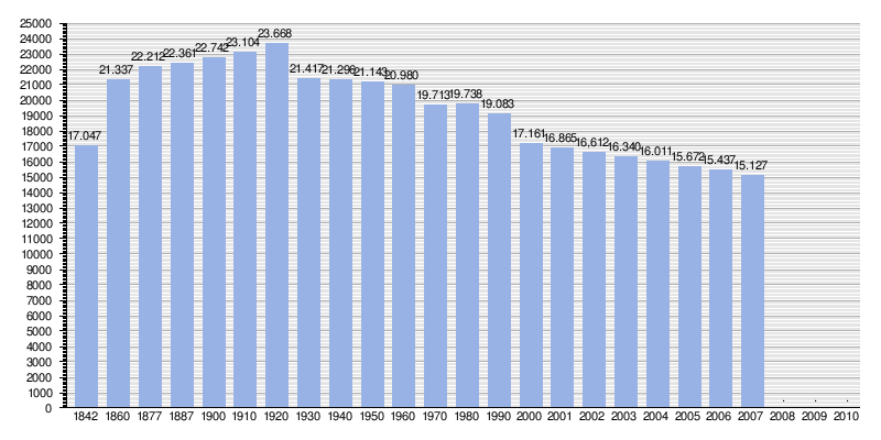
Demography
|
|
|
|
